

Your cart is empty
You may check out all the available products and buy some in the shop
Return to shopContour Surveying is the process of measuring and mapping the natural elevations and depressions of a land area. It provides detailed contour maps that represent the terrain’s shape, slope, and level differences, helping engineers, architects, and developers make informed decisions during project planning and design.
Our contour surveying services utilize advanced surveying equipment and modern techniques to deliver precise topographical data. Whether for construction projects, road development, land subdivision, drainage planning, or infrastructure design, we provide reliable contour maps that support efficient and cost-effective project execution.
Land is rarely flat — and every slope, dip, and elevation change on a site directly affects how it should be designed, drained, and built. A contour surveying Services captures this data precisely, giving architects, engineers, and developers the elevation map they need before finalizing any construction or infrastructure plan.
Skip an accurate contour survey, and you risk poor drainage design, incorrect earthwork volumes, road gradient errors, and water-logging issues that surface only after construction is complete — when they’re expensive to fix.
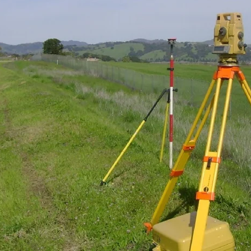
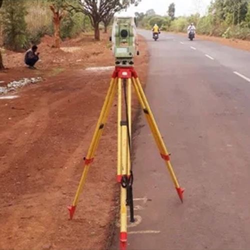
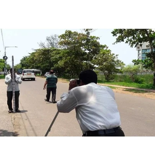
We provide professional contour survey services using drone mapping and total station technology, helping architects, civil engineers, real estate developers, and government project teams get a precise elevation picture of the land — before design work begins.
Our teams currently serve Delhi NCR, and major districts across Uttar Pradesh, Punjab, Haryana, and Himachal Pradesh, covering everything from flat urban plots to steep hilly terrain.
A contour survey maps elevation changes across a piece of land using contour lines — each representing a constant elevation level. This data is critical for:
Without accurate contour data, architects and engineers are essentially designing blind — guessing at elevation instead of working from real measurements.
We work with real estate developers, civil engineering firms, government infrastructure agencies, architects, and agricultural land planners, offering both one-time project surveys and phase-wise elevation data collection.
We are among the most experienced contour survey companies in Delhi NCR, handling projects from compact residential plots to large township and infrastructure developments.
Cities we serve in Delhi NCR:
Delhi, Gurugram, Noida, Greater Noida, Ghaziabad, Faridabad, Sonipat, Panipat, Rohtak, Meerut, Bulandshahr, Alwar, Bhiwadi, Rewari, and Palwal.
Our contour survey services in Gurugram and drone contour survey in Noida are widely used by developers planning residential and commercial projects on uneven plots. We also offer total station contour surveys in Faridabad, Sonipat, and Ghaziabad, supporting accurate drainage and site planning across the region.
If you’re looking for a contour survey company near Alwar, Bhiwadi, or Rewari, our team can mobilize within 24–48 hours with full drone and total station equipment.
From urban plots in Lucknow to agricultural land in Bareilly and Gorakhpur, our team delivers accurate contour survey services across Uttar Pradesh.
Districts we serve:
Lucknow, Kanpur, Agra, Varanasi, Prayagraj (Allahabad), Bareilly, Aligarh, Moradabad, Gorakhpur, Jhansi, Mathura, Saharanpur, Firozabad, and Shahjahanpur.
We provide contour survey services in Lucknow and Kanpur for residential and commercial development, along with drone contour mapping in Agra and Varanasi for large land parcels. Our team has also completed elevation surveys in Bareilly, Aligarh, and Moradabad, supporting both private developers and infrastructure projects.
Punjab’s mix of agricultural land and rapidly growing urban centers requires reliable, accurate contour survey services — and our team delivers exactly that.
Districts we serve:
Ludhiana, Amritsar, Jalandhar, Patiala, Bathinda, Mohali (SAS Nagar), Hoshiarpur, Batala, Moga, Pathankot, Firozpur, Kapurthala, Sangrur, and Rupnagar (Ropar).
We offer contour survey services in Ludhiana and Amritsar for commercial and residential construction, along with total station contour surveys in Jalandhar and Patiala, supporting urban infrastructure projects. Our drone-based contour mapping in Bathinda and Mohali is especially valuable for large agricultural and industrial land assessments.
Beyond the NCR belt, our contour survey services in Haryana support the state’s growing industrial and agricultural land development needs.
Districts we serve:
Hisar, Karnal, Ambala, Yamunanagar, Kurukshetra, Sirsa, Bhiwani, Jind, Kaithal, Fatehabad, Jhajjar, and Mahendragarh.
We provide contour survey services in Hisar and Karnal for industrial and residential projects, along with land contour surveys in Ambala, Yamunanagar, and Kurukshetra, supporting both private developers and government infrastructure works.
Hilly terrain demands specialized surveying expertise — and our team is experienced in handling contour survey services across Himachal Pradesh’s challenging landscapes.
Districts we serve:
Shimla, Mandi, Kangra (Dharamshala), Solan, Una, Bilaspur, Hamirpur, Kullu, Chamba, Sirmaur (Nahan), Kinnaur, and Lahaul and Spiti.
We offer drone contour survey services in Shimla and Mandi, ideal for capturing accurate elevation data across steep and inaccessible terrain. Our total station contour surveys in Solan, Una, and Kullu support residential, hospitality, and infrastructure projects across the hill state, where precise slope data is critical for safe, stable construction.
✅ Multi-state coverage across Delhi NCR, UP, Punjab, Haryana & Himachal Pradesh
✅ Drone + total station technology for fast, high-precision elevation mapping
✅ Experienced with hilly and difficult terrain — not just flat urban plots
✅ Fast mobilization — team on-site within 24–48 hours
✅ Transparent, per-acre pricing — no hidden costs
✅ Trusted by developers, engineers, and infrastructure agencies
1. What is a contour survey?
A contour survey maps elevation changes across a piece of land, showing slopes and elevation levels through contour lines — essential data for drainage, road, and site design.
2. Which locations do you provide contour survey services in?
We currently serve Delhi NCR, and major districts across Uttar Pradesh, Punjab, Haryana, and Himachal Pradesh.
3. Can you do contour surveys on hilly or difficult terrain?
Yes, we specialize in contour surveys across hilly regions like Himachal Pradesh using drone technology combined with total station verification for accuracy.
4. How much does a contour survey cost?
Pricing depends on land size, terrain difficulty, and location — we offer transparent per-acre pricing. Contact us for a customized quote.
5. How is a contour survey different from a topographical survey?
A contour survey focuses specifically on elevation and slope data, while a topographical survey includes contour data plus additional land features like structures, vegetation, and water bodies.
6. How long does a contour survey take to complete?
Turnaround time depends on land size and terrain, but drone-based surveys significantly reduce time for large or hilly land parcels compared to manual methods.
Arya Surveyor provides professional Contouring Survey services to map land elevations, slopes, and terrain variations accurately. Our surveying solutions support site planning, construction, infrastructure development, drainage design, and engineering projects requiring detailed ground-level information.
Arya Surveyor provides reliable Contouring Survey in Nepal to capture land elevations, slopes, and terrain variations. Accurate contour data supports construction, infrastructure, drainage, land development, site planning, and engineering projects across different terrains.
Arya Surveyor offers professional Contouring Survey in Bhutan for mapping elevations, slopes, and terrain conditions. Our survey solutions support infrastructure, construction, land development, drainage planning, and engineering projects requiring accurate ground-level information.
Whether you’re planning a hillside property in Shimla, an industrial plot in Ludhiana, an agricultural project in Bareilly, or a residential development in Gurugram — our experienced survey team delivers the precise elevation data your project needs. Contact us today for a free site assessment and quote.
WhatsApp us
Address: 1234 Fashion Street, Suite 567,
New York, NY 10001
Email: info@fashionshop.com
You may check out all the available products and buy some in the shop
Return to shop